A Trip Down Memory Lane:
The Judgment of the International Court of Justice in
Maritime Delimitation in the Indian Ocean (Somalia v Kenya)
MASSIMO LANDO
Assistant Professor, School of Law, City University of Hong Kong
Global Fellow, Centre for International Law, National University of Singapore
 “Been There, Done That”
One may get used to lack of consistency among judicial decisions. One may even justify lack of consistency when, as in maritime boundary delimitation, they could argue that each case is unique and, therefore, warrants adopting different approaches from those followed in earlier judicial decisions. The comeback should be: “been there, done that”.
The beginnings of judicial maritime delimitation were afflicted by lack of certainty. International tribunals saw each case as unique because of its peculiar geographical setting. There was no generally-applicable methodology to delimit boundaries in the Exclusive Economic Zone (EEZ) and continental shelf. Delimitation was governed by “equitable principles”. There was no “judicial process” for maritime delimitation. Since the 1993 judgment in Jan Mayen, international tribunals have developed such a process. Originally, the process was in two stages: it required establishing a provisional equidistance line and adjusting it based on relevant circumstances. In its 2009 judgment in Black Sea, the International Court of Justice (Court) added a third stage, the disproportionality test. Except for the Court’s 2007 judgment in Nicaragua v Honduras, the two-, and later three-, stage process governed the delimitation of all post-1993 maritime boundaries (for criticism of Nicaragua v Honduras, see here).
One wonders whether the Court’s Somalia v Kenya judgment of 12 October 2021 is a step back on the road to promoting certainty in maritime delimitation. The case seemed quite straightforward. The Court applied the three-stage process without problems, at least in drawing a provisional equidistance line and the disproportionality test. However, the Court’s reasoning justifying the adjustment of the provisional equidistance line is not wholly convincing, mainly because it reminds one of pre-1993 jurisprudence in which promoting certainty appeared hardly to be a concern of judges and arbitrators.
The Court’s judgment has already been the focus of some scholarly commentary (see the blog post by Nicolas A. Ioannides and Constantinos Yiallourides). After a brief overview of the judgment, this blog post will focus on the problems with the Court’s reasoning concerning the adjustment of the provisional equidistance line.
Overview of the Court’s Judgment
Somalia filed a case against Kenya for the delimitation of their maritime boundary in 2014 (Application). After a preliminary phase in which the Court rejected all of Kenya’s objections to jurisdiction and admissibility (here), Kenya continued to engage in the proceedings by submitting its written pleadings, while finally refusing to appear at the oral proceedings on the merits.
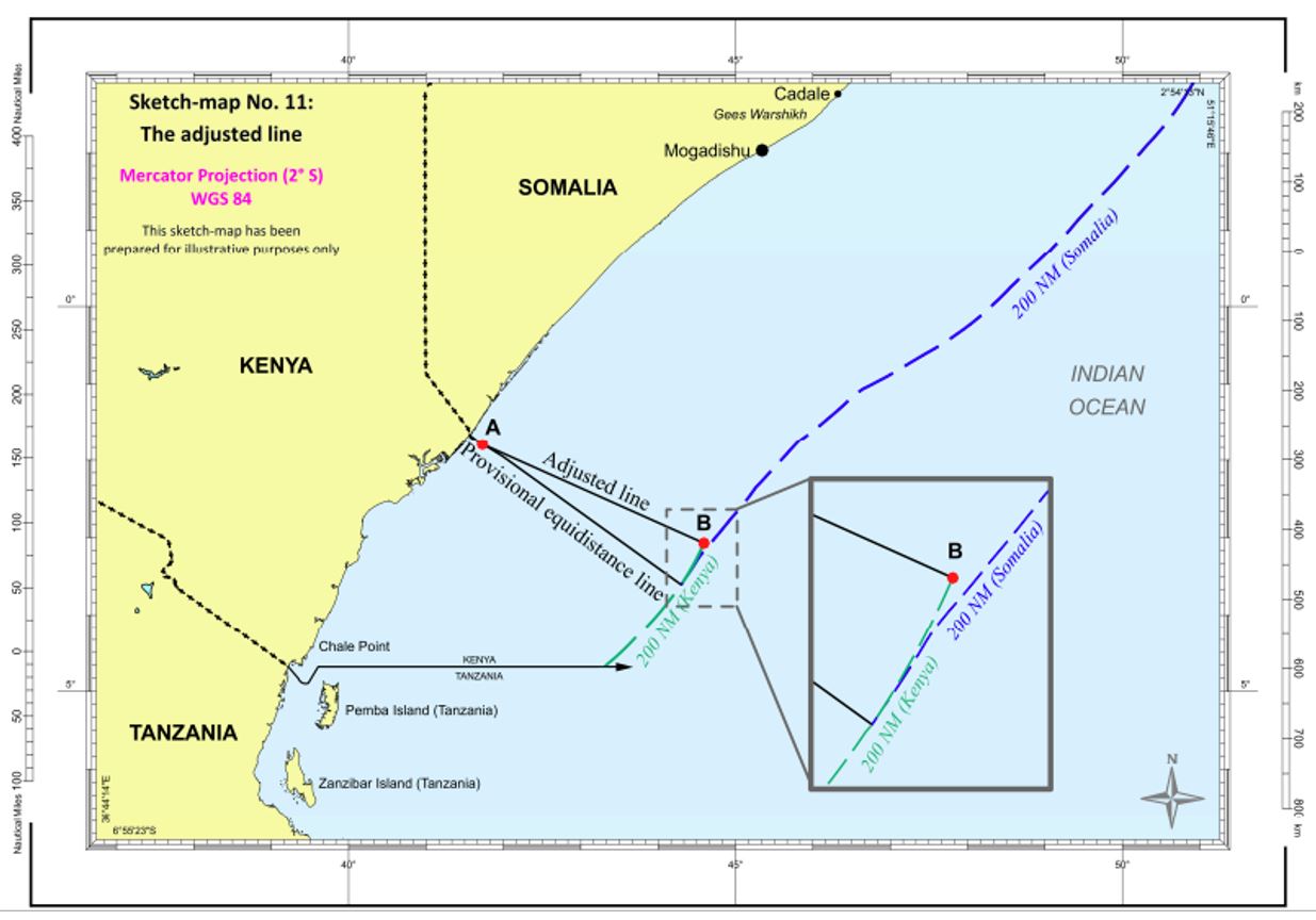
Kenya contended that the parties had tacitly agreed to a maritime boundary along a parallel of latitude passing through the land boundary terminus, which was reminiscent of Chile’s partly-successful argument in the 2014 case against Peru. The Court rejected Kenya’s contention for lack of evidence (paras 36–89). The Court delimited the territorial sea following its established process in two stages (paras 99–118). For the EEZ and continental shelf, the Court found that the three-stage process was applicable in the case (paras 119–131). According to the Court, no circumstances made it “inappropriate” to apply the three-stage process, following the wording of Nicaragua v Honduras, even though the Court should have better stated that there were no “compelling reasons” making it “unfeasible” to draw a provisional equidistance line, following the later threshold formulated in Black Sea. The Court identified the relevant coast and relevant area by means of radial projections (paras 132–141), drew a provisional equidistance line and adjusted it in Kenya’s favour on account of cut-off (paras 142–174 and see map below). Finding that the boundary passed the disproportionality test (paras 175–177), the Court then delimited the continental shelf beyond 200 nautical miles simply by extending the EEZ boundary (paras 178–197).
Somalia had claimed that Kenya’s activities in the undelimited areas breached international law, but the Court rejected this contention (paras 198–213).
Inconsistency with Earlier Case Law
Although Kenya had argued that the boundary should be adjusted based on security and access to natural resources (paras 158–160), the Court adjusted the boundary because a strict equidistance line would have inequitably cut off Kenya’s coastal projections. The reasoning was inconsistent. First, the Court stated that “any cut-off effect as a result of the Kenya-Tanzania maritime boundary is not a relevant circumstance” (para 163), but then added that “examining only the coastlines of the two States concerned to assess the extent of any cut-off effect […] may be an overly narrow approach” (para 164). The Court appears hesitant, as suggested by the use of “may be” instead of the more peremptory “is”. The Court examined the concavity taking into account the coast of a third State, Tanzania, even though cut-off resulting from the Kenya-Tanzania boundary was “not a relevant circumstance”. The Court supported its approach by relying to earlier case law. This reliance was misplaced.
The Court endeavoured to rely Cameroon v Nigeria, as in that case it had found that “the concavity of Cameroon’s coastline is apparent primarily in the sector where it faces Bioko”, an island under the sovereignty of a third State, Equatorial Guinea. However, Equatorial Guinea was an intervening party, and, nevertheless, the Court refused to find any part of its coast to be relevant in delimiting the boundary between Cameroon and Nigeria. Most importantly, the Court did not adjust the provisional equidistance line because of cut-off as a consequence of the concavity of Cameroon’s coastline being apparent in the sector where it faces Bioko (Cameroon v Nigeria, para 297). Cameroon v Nigeria cannot support the Court’s decision to consider Tanzania’s coast in assessing the cut-off of Kenya’s coastal projections.
The Court could not rely on North Sea Continental Shelf, because that was a case in which all States whose coast contribute to cutting off Germany’s coastal projections were parties before it. The Court’s reference to the statement, in North Sea Continental Shelf, that it was faced with a single situation overlooks that the cited paragraph closed by emphasising that the problem that the Court had to deal with mostly resulted from all parties arguing the case by reference to their three distinct coastlines (North Sea Continental Shelf, para 11). This situation was dissimilar from Somalia v Kenya, in which Somalia had not argued its case by reference to the coast of a third State.
The Court cited Bangladesh/Myanmar and Bangladesh v India, stating that the International Tribunal for the Law of the Sea (ITLOS) and the arbitral tribunal had considered the concavity formed by all three States abutting the northern Bay of Bengal. This statement may be true for Bangladesh v India, although the tribunal stated that it would consider the three-State concavity after deciding that it would “base its decision solely on consideration of the relationship between Bangladesh and India and their respective coastlines” (para 411). However, the Court’s statement is not true for Bangladesh/Myanmar. In Bangladesh/Myanmar, ITLOS referred to the concavity formed only by Bangladesh’s coast (“[t]he Tribunal observes that the coast of Bangladesh, seen as a whole, is manifestly concave”, para 291). There was no direct reference to India’s contribution to cut-off. Even if ITLOS could be seen to have considered India’s coast, the case could resemble North Sea Continental Shelf, because, by the time ITLOS decided Bangladesh/Myanmar, Bangladesh had already filed arbitral proceedings against India. ITLOS judges knew that, within few years, both boundaries between Bangladesh and its neighbours would be delimited. That consideration appears sufficient to justify looking at the coast of India.
The Court was broadly correct in its assessment of the Guinea/Guinea-Bissau arbitral award, but its analysis left out the parts of that award that would have justified not relying on it to decide Somalia v Kenya. In Guinea/Guinea-Bissau, the arbitral tribunal drew no provisional equidistance line, but bisected the angle formed by the line connecting Point Almadies, in Senegal, to Cape Shilling, in Sierra Leone. As the arbitral tribunal did not adjust any provisional equidistance line, one doubts the appropriateness of referring to its award to support the view that cut-off should be assessed “in a broader geographical configuration” (Somalia v Kenya, para 167). Moreover, and perhaps most importantly for systemic reasons, the Guinea/Guinea-Bissau award was written when international tribunals approached each delimitation case as a unicum: first, the Court should be slow to adopt the award’s approach, tailored as it was to the geographical situation of Guinea and Guinea-Bissau; second, adopting the award’s approach promotes turning the clock back to a time when certainty was not a concern uppermost in the mind of delimitation judges and arbitrators.
Assessment and Implications
The obvious implication of the Court’s problematic treatment of cut-off in Somalia v Kenya is the reduced cogency of its reasoning. The judgment has already been criticised from within the Court itself on this basis (see the individual opinions of Judges Abraham, Yusuf and Robinson).
One could sympathise with the Court, nonetheless. The situation in which the Court found itself was not enviable. The north-eastwards direction of Somalia’s coast, compared to the broadly north-south-oriented Tanzanian and Kenyan coasts, could have been a problem in and of itself when considering the cut-off resulting from a provisional equidistance line. The 2009 Kenya-Tanzania agreed boundary, running along a parallel of latitude, complicated the geographical situation. While this agreed boundary appears to be an equitable, even sensible, solution when taken in isolation, it becomes quite problematic when put into the wider context of the East African boundary system. Treaty negotiators could have expected Somalia to argue, whether in negotiations or adjudication, for an equidistance boundary. The primacy of equidistance was already established when the Kenya-Tanzania boundary was being negotiated; moreover, a glance at the geography of the East Africa should suffice to guess that equidistance would be favourable to Somalia. Even looking at the Kenya-Tanzania coasts, one could detect some concavity that could have justified not drawing a boundary along a parallel of latitude, but one in a south-easterly direction, veering towards Tanzania’s coast. If that had been the Kenya-Tanzania agreed boundary, the Court might not have felt compelled to engage in legal gymnastics to justify considering Tanzania’s coast to determine whether a provisional equidistance line with Somalia would inequitably cut off Kenya’s coastal projections.
Kenya manifested its displeasure with the case by refusing to appear in the oral proceedings. Even if the Court might have somewhat appeased Kenya’s concerns with being cut off from part of its maritime jurisdiction, it did do at the expense of Somalia’s goodwill. The question that arises is, as usual, that of compliance. With a displeased Kenya, the Court could have counted on Somalia’s intent to comply; a (perhaps less) displeased Kenya and Somalia losing a share of waters that could have been under its jurisdiction raises question marks on implementation.
The Court’s decision harkens back to a time when States did not know what to expect when getting involved in judicial maritime delimitation. It took from 1969 to 1993 to overcome wild uncertainty in the delimitation methodology. Somalia v Kenya does not throw all of that effort out of the window, but it can be a significant step back, especially if followed in upcoming maritime delimitation cases such as Nicaragua v Colombia II, Equatorial Guinea/Gabon and Mauritius/Maldives.
A Trip Down Memory Lane
One can hope that Somalia v Kenya was only a trip down memory lane. It may seem that the Court’s approach to cut-off in Somalia v Kenya is not that problematic and that it is unlikely to foreshadow a return to pre-1993 maritime delimitation. The three-stage process is so well-entrenched that, to show that international tribunals should not use it in future cases, States bear a high burden. Even if that were true, it would remain that, by its approach in Somalia v Kenya, the Court gave itself greater discretion to assess whether cut-off justifies adjusting a provisional equidistance line. This greater discretion is more problematic considering that cut-off is the relevant circumstance responsible for most adjustments of provisional equidistance lines so far (see here). What appears on examination is that the Court’s approach was unpersuasive at best, ill-advised at worst.
________________________